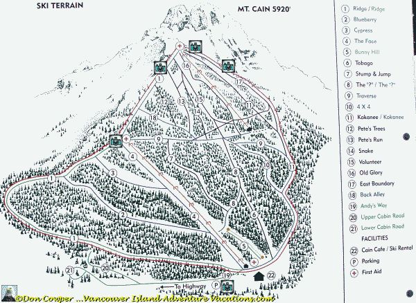
The Mt Cain Ski Area Trail Map, Vancouver Island - Come Have a Peak.
The Mt. Cain composite picture shown below was created from five pictures I took near the top of the upper T-bar. Talk about a lunch spot with a million dollar view! You can find the individual pictures on this page.

Below is a trail map of the Mt. Cain ski area. Click on the blue camera icons to access snow scenes taken from that location on the hill. Click your back button or the "Return to the Mt Cain Trail Map" links to return to this page.

Mt Cain is one of a dying breed of community owned ski facilities in Canada. In 2005 it was voted as one of Canada's best in class by Ski Canada. It is normally only open on weekends and school holidays. Because of this the weekends often bring accumulated knee deep powder.
Each snow scene will have an arrow in the bottom right hand corner that shows the direction I was looking when I took the shot. All arrows are in reference to this map. An arrow to the right means I turned 90 degrees to the right and took the shot. Down is towards the bottom of the map (and the hill for that matter). Up is towards the top of the map and the hill. Enjoy!
If you have problems with the map or can't see the camera icons, text links follow:
- Mt. Cain, the Road up and Parking Lot - Come for a Skiing Holiday- Mt Cain Lunch Spot - Snow Scene Gallery
- East Bowl Snow Scene Gallery - Mt. Cain, Vancouver Island.
- Skiing Picture Gallery - West Bowl Regional Park, Mt. Cain
- Skiing Picture Gallery - Top of Bottom T-Bar, Mt Cain.
